TAMPA, Fla. (WFLA) — A tropical depression is expected to form sometime this week in the western Caribbean Sea, according to the National Hurricane Center.
The area of low pressure resembles a similar path to Hurricane Helene, which charged rapidly through Florida and the southern region of the U.S., leaving at least 64 dead as of Saturday night.
Over the next few days, gradual development of this potential disturbance is expected, and a tropical depression “could form” around the middle part of the week, NHC said on Sunday. As of the 6 p.m. update, it has a 50% chance of development over the next seven days.
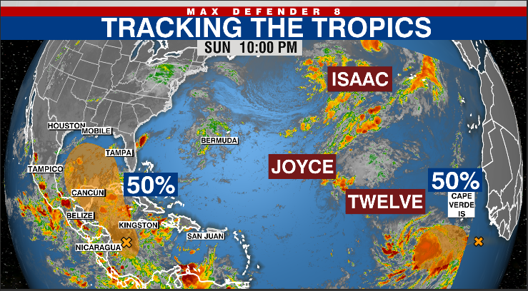
“There are two other areas we are watching. One area of low pressure in the south-central Caribbean will slowly develop. This has a 50% chance of development in the next seven days, but models strengthen this slowly over the western Gulf of Mexico. A tropical depression is expected to develop by the middle of next week. We will closely monitor this system, but it appears as though this will be a much weaker system,” Max Defender 8 Meteorologist Eric Stone said.
As it is forecasted to move northwestward into the Gulf of Mexico, the hurricane center advises the U.S. Gulf Coast to “monitor its progress.”
New wave off the African coast
A brand new wave has emerged off the African coast, with a 50% chance of development over the next week as it moves west-northwest.
“There’s a brand new wave that just emerged off the African coast and right now has a 50% chance of development as it moves to the west and northwest. Some gradual development is possible later next week,” Stone said.
Out in the Eastern Atlantic are Hurricane Isaac and Tropical Storm Joyce. Both systems will not impact the U.S. and are gradually weakening over open water.
Watch Tracking the Tropics on Tuesdays at 12:30 p.m. ET/11:30 a.m. CT.
Be prepared with the 2024 Hurricane Guide and stay ahead of tropical development with the Tracking the Tropics newsletter.