This is an archived story and is no longer being updated. For the latest updates, click here.
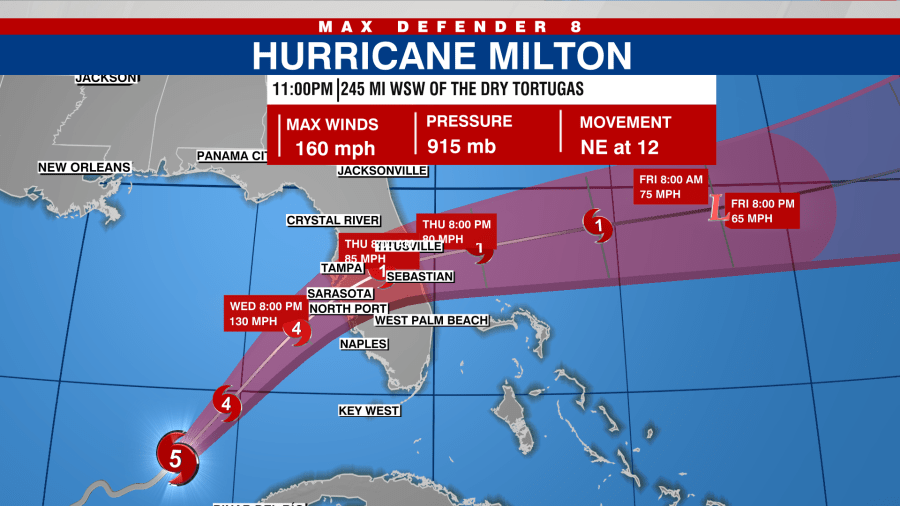
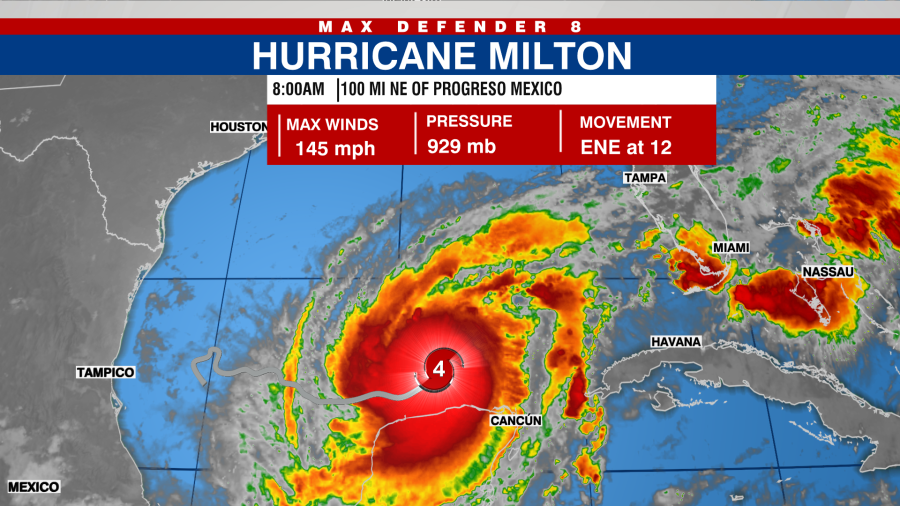
TAMPA, Fla. (WFLA) — Hurricane Milton strengthened into an “extremely powerful” Category 5 Hurricane as it moved toward Florida on Tuesday.
Located about 405 miles southwest of Tampa, Milton is expected to take a turn toward the northeast overnight into Wednesday, according to the National Hurricane Center’s 11 p.m. update.
According to the NHC, Milton is expected to fluctuate in intensity and expand in size, but is forecast to remain an “extremely powerful” hurricane through landfall.
Milton is currently moving toward the northeast at 12 mph with winds of 160 mph.
Watches and Warnings
A Storm Surge Warning is in effect for…
- West coast of Florida from Flamingo northward to the Suwannee
River, including Charlotte Harbor and Tampa Bay - East coast of Florida from Port Canaveral northward to the mouth
of the St. Mary’s River, including the St. Johns River.
A Hurricane Warning is in effect for…
- Celestun to Rio Lagartos
- Florida west coast from Bonita Beach northward to the mouth of the
Suwannee River, including Tampa Bay - Florida east coast from the Indian River/St. Lucie County Line
northward to Ponte Vedra Beach
A Storm Surge Watch is in effect for…
- South of Port Canaveral to Sebastian Inlet
- Mouth of the St. Mary’s River to Edisto Beach
A Hurricane Watch is in effect for…
- Rio Lagartos to Cabo Catoche
- Dry Tortugas
- Lake Okeechobee
- Florida west coast from Chokoloskee to south of Bonita Beach
- Florida east coast north of Ponte Vedra Beach to the mouth of the
St. Mary’s River
- Trump’s vow to end birthright citizenship could face legal challenges, GOP skeptics
- House from ‘Home Alone’ is for sale — but it’s not Kevin McCallister’s house
- NCIS TV Star Mark Harmon & technical advisor Leon Carroll Jr. discuss new book “Ghosts of Panama” with Gayle Guyardo
- Mother arrested after posting video of herself kicking infant: police
A Tropical Storm Warning is in effect for…
- Rio Lagartos to Cancun
- All of the Florida Keys, including Dry Tortugas and Florida Bay
- Lake Okeechobee
- Florida west coast from Flamingo to south of Bonita Beach
- Florida west coast from north of the mouth of the Suwanee River to
Indian Pass - Florida east coast south of the Indian River/St. Lucie County
Line to Flamingo - Florida east coast north of Ponte Vedra Beach to the mouth of the
St. Mary’s River
A Tropical Storm Watch is in effect for…
- Coast of Georgia and South Carolina from north of the mouth of the
St. Marys River to South Santee River, South Carolina - Extreme northwestern Bahamas, including Grand Bahama Island,
the Abacos, and Bimini.
Some areas that are normally dry near the coast could be flooded due to rising waters moving inland.
- Anclote River, FL to Englewood, FL: 10-15 feet
- Tampa Bay: 10-15 feet
- Englewood, FL to Bonita Beach, FL: 6-10 feet
- Charlotte Harbor: 6-10 feet
- Yankeetown, FL to Anclote River: 5-10 feet
- Bonita Beach, FL to Chokoloskee, FL: 4-10 feet
- Suwannee River, FL to Yankeetown, FL: 3-5 feet
Watch Tracking the Tropics on Tuesdays at 12:30 p.m. ET/11:30 a.m. CT.
Be prepared with the 2024 Hurricane Guide and stay ahead of tropical development with the Tracking the Tropics newsletter.