Jeff Berardelli is WFLA’s Chief Meteorologist and Climate Specialist
It’s nearly two weeks after Milton, and people in the Tampa Bay area are still dealing with the ongoing impacts of the storm.
Along the Withlacoochee River, “major” flooding is still occurring from eastern Pasco to eastern Citrus counties — and in some cases, the river is still rising.
Meanwhile, out in the Gulf of Mexico, a large area of red tide has blossomed, with the possibility of fish kills and respiratory distress in our future.
There is an obvious A to B connection from heavy rainfall in hurricanes to river flooding, but the connection between hurricanes and red tide is less obvious and more difficult to prove beyond the shadow of a doubt.
Still after Hurricane Irma, Hurricane Ian, and now after the Helene-Milton duo, red tide is rampant.
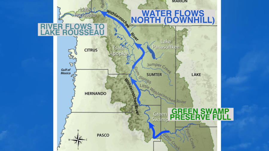
Let’s start with river flooding. In what may seem like a twist, the northern part of the Withlacoochee River in Citrus County is rising, while the southern extent in Pasco is finally falling. That’s because the river actually flows south to north.
A foot of rain fell on the watershed during Milton and that was on top of an already very wet rainy season. That caused the Green Swamp, which feeds the river, to become swollen and consequently water is gradually building up in the river.
Below you can see how the river is fed and flows from the south near the Green Swamp, northward towards Lake Rousseau. Contrary to popular belief, rivers don’t always flow south, but they always flow downhill. In other words, the terrain near Green Swamp is somewhat higher than it is near Lake Rousseau.
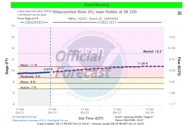
Homes along the Withlacoochee River remain submerged in feet of water. The river in eastern Pasco and Hernando has crested just below record stage and is now slowly falling. Water levels should fall a couple of feet and drop below major, into moderate flood stage, by next week.
But in eastern Citrus County, the river is still rising and may reach major flooding by early next week. Residents are advised to stay aware of river levels and leave if needed.
In the Gulf, a Red Tide outbreak is underway. In the below image, you can see the large area of algae being picked up on satellite. If you look closely enough you can see some red, orange, and yellow dots — overlayed on top of the colored satellite imagery — offshore of Pinellas County. Those dots represent measured concentrations of Karenia brevis, otherwise known as red tide.

Red Tide occurs naturally in the Gulf and can happen without the passage of hurricanes. But scientists say hurricanes can make the blooms worse by upwelling nutrients from down below and forcing rainwater runoff — full of nutrients like fertilizer — from land into the Gulf. Warmer water — amplified by climate change — can also enhance the blooms.
Richard Stumpf, an oceanographer with the National Oceanic and Atmospheric Administration, explained the connection between hurricanes and red tide to the Associated Press.
“Hurricanes do bring up deeper water in the Gulf of Mexico, which has more nutrients,” he said. “They also could produce a lot of rain. You have runoff from the land, which also adds nutrients. It tends to intensify a bloom that’s already there.”
Although some higher concentrations were found around 10 miles offshore of Clearwater and Indian Rocks Beach, as of Oct. 17, concentrations near the coast were still very low. At low levels, red tide does not cause fish kills and respiratory distress. But if concentrations increase near the beaches, the red tide could become more of a problem.