Jeff Berardelli is WFLA’s Chief Meteorologist and Climate Specialist
TAMPA, Fla. (WFLA) — If you are thinking, ‘Boy, was this a sweltering summer!’ You are right. But that was more so due to steamy humidity than it was extreme temperatures.
While it was a hot summer in Tampa — the fourth hottest since records have been kept in 1890 — it was not the hottest summer on record, which goes to last summer 2023.
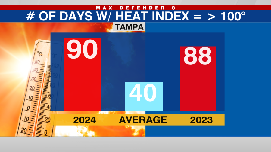
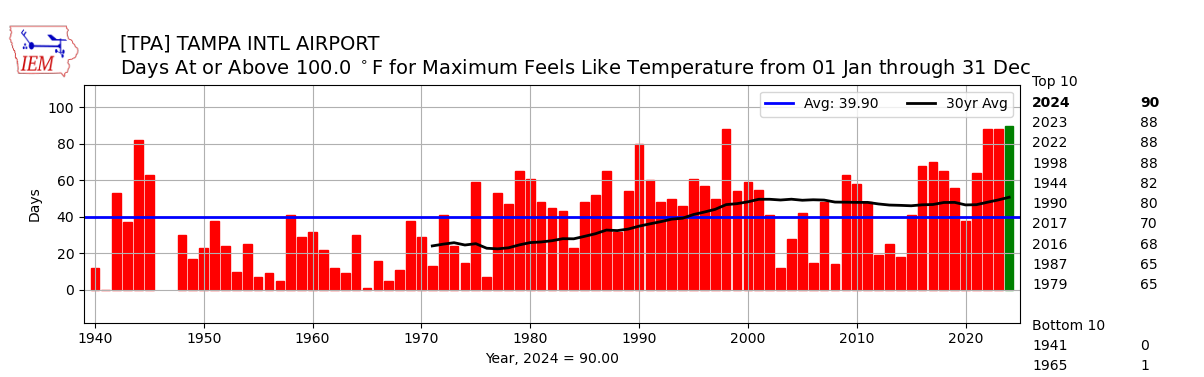
What makes the summer of 2024 the most oppressive since records have been kept on this (1940), were the heat index numbers. Since May 2024, Tampa’s official reporting site, Tampa International Airport, has had 90 days with a heat index of 100 degrees Fahrenheit or higher. That beats 88 days set in 2023, 2022, and the super El Niño year of 1998.
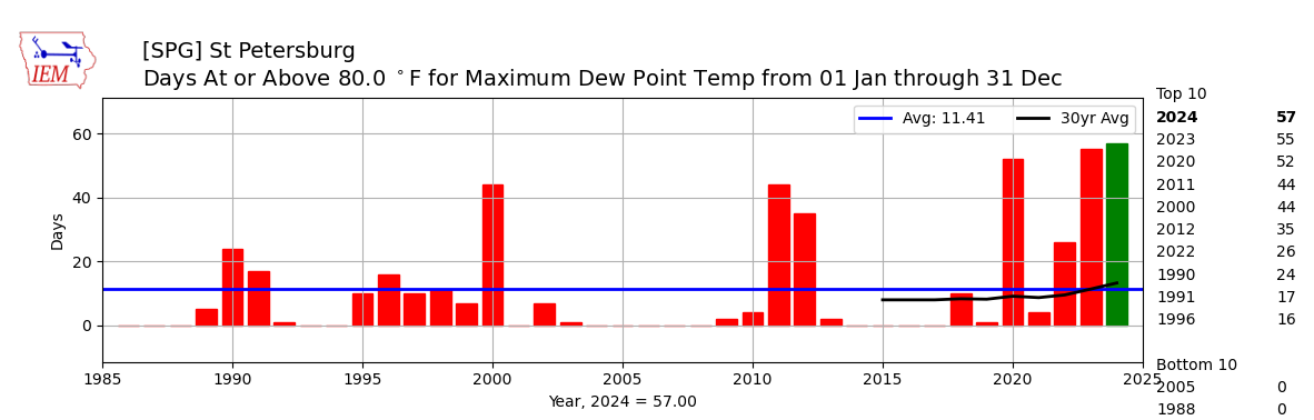
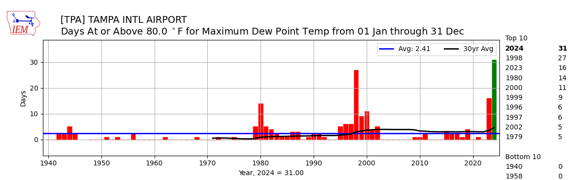
What determines the extent of the heat index, or feels like temperature, is more so humidity than it is heat. And in this regard, 2024 also takes the cake. So far in 2024, Tampa International Airport has recorded 31 days with a dewpoint over 80, almost doubling last year which took third place, and 1998, which tallied 27.
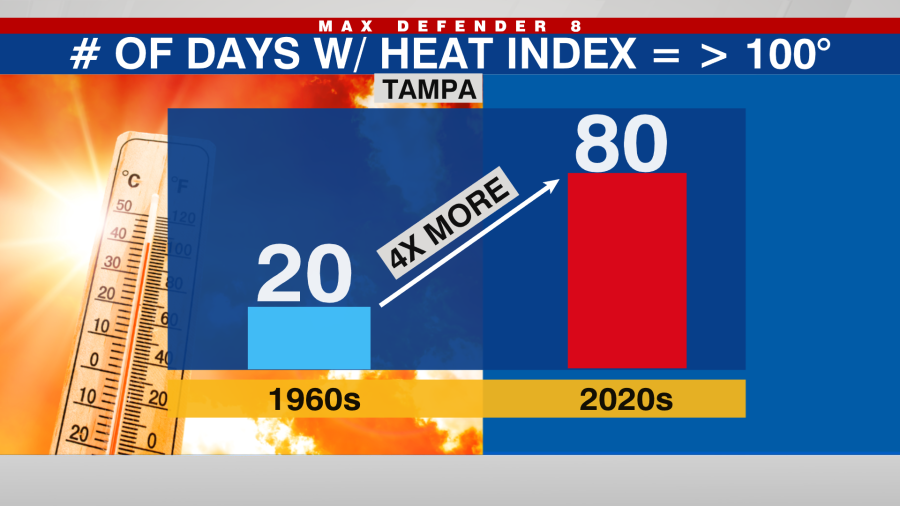
2024 is not a one-off year. When you look at the years with the most heat index numbers at oppressive levels, there is a clear increasing trend with 2022 and 2023 coming in second place. The long-term average is 40 days at or above 100F for a heat index.
But in the 1950s and 1960s, when the climate was cooler and there was less moisture in the air, Tampa only averaged 20 heat index days of 100+ per summer. In recent years that number has increased by an astonishing four times more!
So why are our summers getting more unbearable? It’s not a coincidence, it’s climate change.
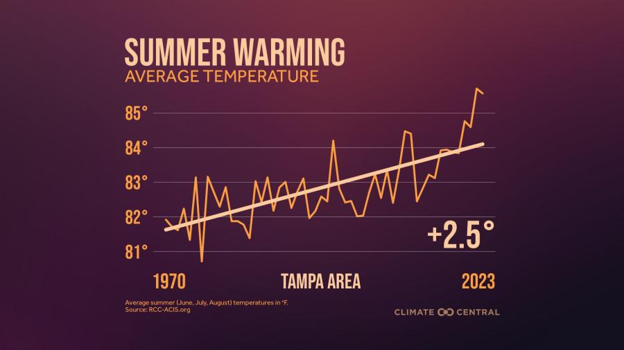
Since 1970 Tampa summers have gotten 2.5 degrees warmer. This is due to both Urban Heat Island from the build-up and expansion of the city, which traps more heat. And it is also due to global warming from the burning of fossil fuels and the release of heat-trapping greenhouse gases.
Adding insult to injury, the Gulf of Mexico is also warming — an increase of around 2 degrees F since the 1970s and 80s. Pictured below is the increasing trend of April-October Gulf Temperatures.
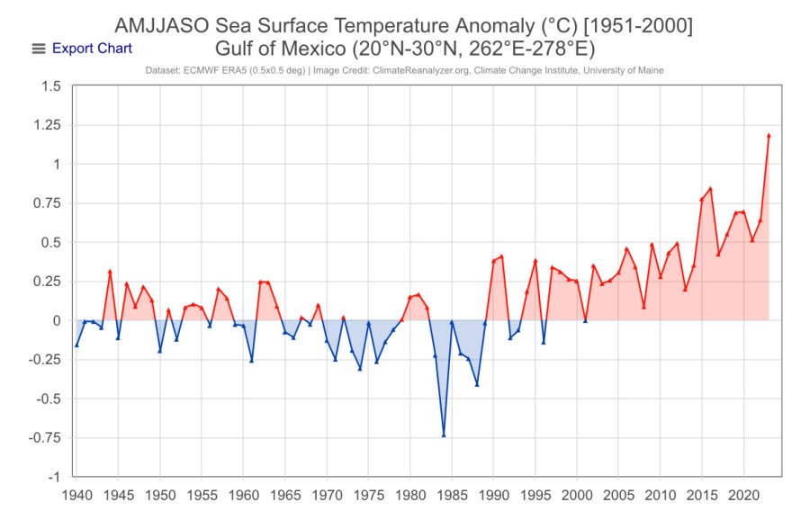
When both air and water temperatures warm, this allows more humidity to be stored in the overlying atmosphere. This explains why the dewpoints have been rising, making for more humid summers.
Obviously, this general trend towards more oppressive summers will continue as long as we continue to heat the air through human-caused climate change.
Now time for some definitions and some charts:
The dewpoint is an absolute measure of how much moisture is in the air. Simply the higher the number the more moist the air is. Heat Index is a calculation taking into account both temperature and dewpoint.
Here are some graphs to show how both dewpoint and heat index are changing.
Heat Index Tampa:
Dewpoint Tampa:
Dewpoint St Petersburg: